Flood Data North Texas is a Regional Flood Warning Software Platform that provides a comprehensive look at rainfall and water levels across the North Texas region through a connected network of flood gauges made possible through partnerships with local municipalities and agencies.
HydroLynx
HydroLynx Systems, Inc. manufactures real-time data telemetry systems. HydroLynx systems provide customers with accurate and timely hydrological data, allowing customers to make decisions that protect lives and property in their communities. Building on the many years of experience as leaders in the ALERT and IFLOWS flood warning systems industry, HydroLynx's state‐of‐the‐art equipment allows them to offer Supervisory Control And Data Acquisition (SCADA) systems among their extensive customer base which includes federal, state, and local government agencies, as well as many agencies in foreign countries.

OneRain
OneRain, an AEM brand, provides advanced flood early warning management through the AEM Elements™ 360 application. Integrating diverse data sources – from rainfall sensors and stream gauges to gauge-adjusted radar rainfall (GARR) and inundation maps – the software serves as a command center for enhanced situational awareness. Customizable, interactive dashboards, maps, and graphs give agencies a clear view of evolving conditions for timely, informed responses. Automated alerts ensure critical information reaches teams precisely when needed. By streamlining data sharing and enhancing collaboration, AEM Elements 360 enables agencies to make faster, more effective flood risk management decisions.
TriLynx
TriLynx utilizes NovaStar5, which is recognized as the industry leader for real-time hydrological data collection, management, and notification. TriLynx staff are experts at installing and supporting NovaStar5 and lead several organizations in the development of and use of water resources software tools. Along with the integration of ALERT/ALERT2 field equipment and telemetry systems, TriLynx will continue to lead WET parallel to TriLynx. TriLynx continues to reach out to existing clients to collect feedback on the NovaStar5 product, to continue providing excellent client service and enhance current and future products.
Disclaimer: FloodDataNTX is an interactive mapping application developed by the North Central Texas Council of Governments through a cooperative contract with OneRain, Inc. The data and information presented may not be presented in real-time and should not be assumed to be exact conditions in the indicated area on the map. Neither FloodDataNTX nor the sponsoring agencies including the North Central Texas Council of Governments and member municipalities participating in this program assume any legal liability or responsibility, or make any guarantees or warranties as to the accuracy, completeness, or suitability of the information for any specific purpose. The public is urged to closely monitor information provided by local emergency management organizations during emergency situations.
OneRain Forecast Map
What is Flood Data North Texas?
The Regional Flood Warning Software Platform is a cooperative contract of TXShare, created with the NCTCOG Environment and Development Department and member communities of the Flood Management Task Force. The goals of the platform are to provide access to flood warning software for communities at a lower cost and to allow communities one common platform to view and interact with flood gauges and provide better resources for planning and response as storms track across the region.
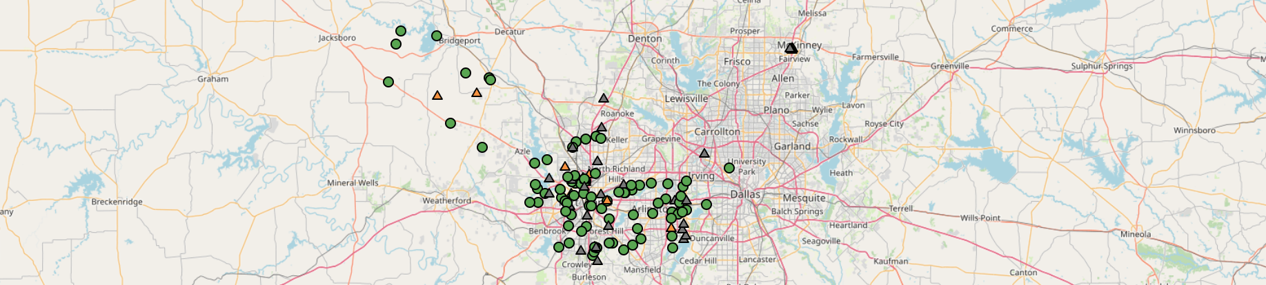
The North Central Texas region is home to several hydrologic gauging networks used for a wide variety of purposes, including flood warning, water management, and dam safety. However, agencies that have few or no gauges are left without an easy way to understand how rain and flooding are impacting their system. The Regional Flood Warning Software Program provides access to an enterprise-level hydrologic software, called Contrail, to help them understand approaching storms, monitor the impacts on their agency, and provide their constituents with information through the website.
The program collects gauge data from all surrounding gauging networks, including the cities of Fort Worth, Dallas, and Grand Prairie, as well as Tarrant Regional Water District, USGS, and METAR gauges. If available, participating entities can bring in their own gauge data to the system and share that data for the benefit of the region. Within the software, the agency can visualize the data through advanced mapping, dashboards, and graphs. Specific thresholds can be set to be alarmed through SMS or email. StormData™ Gauge-Adjusted Radar Rainfall will provide rainfall estimation over the entire region, including over a participating entity's area, which can be used if no rain gauges are present. All data are stored for future analysis and post-event reports.
How Communities Can Join
The Regional Flood Warning Software Platform is a cooperative contract of TXShare, created with the NCTCOG Environment and Development Department and member communities of the Flood Management Task Force. If a community would like to join the contract, can can do so by entering into an interlocal agreement with the North Central Texas Council of Governments. For more information, and to apply to join FloodDataNtx, please visit https://txshare.org.